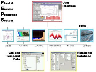
The FEPS is a deterministic modeling tool that links GIS technology, engineering
models, automated mapping tools and custom visualization in a modular system.
Two actual implementations are described below:
-
The Lake Michigan Potential Damages Study (LMPDS) was initiated in 1996 by the
US Army Corps of Engineers, Detroit District. The ultimate goal of the LMPDS is
to develop a defensible approach to estimate potential lake-wide economic and
environmental damages resulting from future extreme lake levels and altered
climate scenarios. The mapping and spatial data from the FEPS is an integral
part of the Economic Impact Assessment for the Potential Damages Study.
-
The International Joint Commission (IJC) is presently re-evaluating the operational
procedures for the Moses-Saunders power dam in Massena, New York, which controls
the water levels of Lake Ontario and the flows in the St. Lawrence river. The FEPS
was a critical tool used to evaluate the impacts of water levels for the alternative
plans under consideration on flooding and erosion hazards for riparian property.
The functionality in the various modules of the FEPS is summarized below:
-
Assemble and process time series wave, water level and ice records, and export
data for input to engineering models
-
Automated GIS tools to extract 2D profiles, measure erosion transects, and
populate property parcel database
-
Application of the COSMOS coastal processes model to predict rates of sediment transport,
beach and dune erosion, recession of bluff shorelines, and wave runup and overtopping
predictions on an hourly basis
-
Detailed tools to quantify sediment sources, sinks and transport pathways for sediment
budgets
-
Complex algorithms to predict rates of inundation and damage due to wave forces on
structures for time series water levels, surge and waves
-
Custom visualization tools, including 2D maps and 3D animation capabilities in ArcScene