|
Spatial Data Analyzer Animations |
|
|
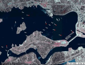
Keta Sea Defense - Flood Control Structure Baird were the prime consultant providing all phases of design and engineering services during construction for the USD87 million Keta Sea Defense Project in Ghana, West Africa, completed in 2003. This SDA animation shows a short clip of the Baird in-house 3D finite element model results used to support the Flood Control Structure (FCS) design. The FCS now regulates flow between the 200 km2 Keta Lagoon and the sea and is constructed within a causeway supporting a highway. Previously, the lagoon had no natural outlet to relieve flooding associated with it's three tributaries. Historically, lagoon flooding was relieved by creating a breach in the barrier beach, a dangerous process that was difficult to control due to the size of the tidal prism of Keta Lagoon. The breach also was difficult to close and would result in erosion impact to downdrift communities as the inlet migrated alongshore. With the FCS in place, the main part of Keta Lagoon can be isolated from the sea allowing the breach to be opened and closed in a controlled manner. The 3D model was used to design the number of bays required in the Flood Control Structure and to determine the performance and operational guidelines for flood control. In addition to the FCS, other components of the Keta Sea Defense Project included: headlands and beach nourishment, a storm protection berm, land reclamation and reconstruction of a coastal highway. |
|
|
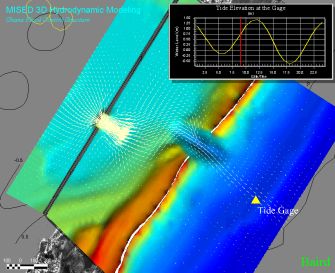
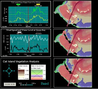
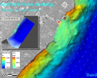
Cat Island Chain Restoration, Green Bay, Wisconsin, USA The Cat Island chain of islands, located at the south end of Green Bay, was severely eroded during high water levels and extreme wave attack in the early 1970s. It is believed that the loss of the above water part of the islands was responsible in whole or part for the loss of almost 700 acres of emergent and submerged aquatic vegetation in the lee of the islands. In addition to these indirect impacts, the terrestrial habitat of the islands themselves was also directly lost. The US Fish & Wildlife, Brown County and the US Army Corps of Engineers plan to restore the islands through beneficial use of clean dredged sediment from the Green Bay Federal Navigation Channel. Baird were retained to develop conceptual and preliminary design for the restoration of the islands. SDA was used to evaluate the potential survival of submerged aquatic vegetation (SAV) with different island configurations as shown in the right hand panels of the animation (top - existing, no islands; middle - three islands; bottom panel - three islands and a land connection with a string of smaller islands). SDA was used to overlap the two key factors influencing SAV survival: water clarity (Secchi Disk measure), which was derived from a numerical model of lake bed resuspension and plumes from two nearby rivers (the Fox River being one) completed by Baird; together with the influence of flow velocities on plants (combined orbital velocity/hydrodynamic) - the maximum allowable flow for survival was 0.6 m/s (information was derived from wave and hydrodynamic models). The left hand panels track the key environmental parameters through the course of the animation including: river discharge, TSS, water levels and wave heights. |
|
|
Halton Intake, Oakville, Ontario, Canada Baird were retained on this project to providing information on turbidity levels along the shore of Lake Ontario to support the siting of an intake for a new water filtration plant. The main influences on turbidity were plumes from three nearby rivers, local resuspension of sediment from the lake bed and regional resuspension and transport of sediment load from other areas of the lake. SDA was used to visualize the results of 2D models (MIKE21) of hydrodynamics and advection dispersion for a range of results. |
|
|
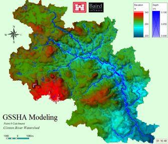
Clinton River Watershed, north of Detroit, Michigan, USA Baird were retained to develop a watershed modeling system to simulate hydrology, river flows and sediment loads for this watershed. The modeling system was transferred to the local community to be used as a management tool for assessing impacts on sediment loading through land use changes (mostly urbanization) and best management practices associated with urbanization. The three main components of the modeling system were the SWAT model for the overall watershed, the GSSHA model of selected subwatersheds and the 3D model (EFDC) of hydrodynamics and sediment dynamics. The SWAT and GSSHA models simulate rainfall/runoff and sediment yield and route the water and sediment through the watershed. The animation shows the rainfall/runoff output from GSSHA for the Paint Creek subwatershed. The rainfall falls evenly over the watershed and then is collected and routed through the landscape by the distributed/gridded model. |
|
|
Eel Tracking in the St. Lawrence River Animated results of an acoustic telemetry study with tagged eels migrating downstream through the Moses-Saunders Dam on the St. Lawrence River near Massena, New York. SDA provided the ability to create, edit, and visualize eel tracks based upon the telemetry data. Here, several non-synchronous eel paths are compared in the area near the dam. |
|
|
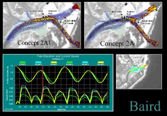
Bhavanapadu Fishing Harbor, Andhra Pradesh, India Soon after its construction in the 1970s the entrance to this fishing harbor on the east coast of India filled with sediment making it all but unpassable for anything but small fishing canoes. Baird were retained to develop solutions to the sedimentation problem and considered a range of options from mechanical bypassing plants to revised channel alignments. Flows through the channel are mostly tidally driven with some freshwater input. The SDA animation shows hydrodynamic and particle tracking results for three model runs: the existing conditions (small panel to right); a new channel alignment and the old one closed (Concept 2A1); both the new channel and the old one open (Concept 2A). The time series panels show the water levels and flow velocities predicted with each of the three model runs at the location of the existing docks on the north side just before the confluence. |
|
|
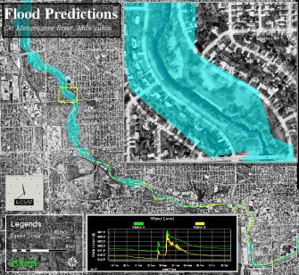
Menomonee River, Milwaukee, Wisconsin, USA Baird completed the development of a watershed-based sediment transport model for the Menomonee River. The watershed-based modeling system provides a tool for managing and visualizing a wide range of dynamic data related to sediment, water quality, flooding, restoration and habitat issues. Here data from a 1D hydraulic model of the river is overlaid on an orthoimage of the City of Milwaukee, highlighting areas prone to flooding. |
|