|
X-Vision Animations |
|
|
Image Draping and Dynamic Simulations This demonstrates combining GIS data such as aerial photography and DEMs in the same 3D environment as dynamic numerical model results. Here we see a 2D MIKE 21 advection/dispersion simulation shown with ortho-imagery draped over topography. This model run represents a simulation of contaminants overflowing from an inland lagoon, across a beach, and into the ocean. This situation will arise after a heavy rainfall, and is a health concern for the adjacent pristine beaches, as well as an ecological concern for the reef. The simulations undertaken provide a clear picture of the complex and dynamic processes which are occurring in a manner which is easy to understand. It also provides a useful and efficient method for engineers and scientists to analyze the numerous numerical modeling results necessary to study the hydrodynamic processes which occur in this environment. |
|
|
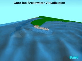
Predicted wave conditions post construction This animation shows a combination of a number of X-Vision features, including an animated transparent wave surface and a breakwater covered with Core-Loc armor units. The wave field shows the interaction with the breakwater (located in Hawaii) and the diffraction pattern behind the structure. The breakwater is created through a VRML model of a single Core-Loc unit. Placement of each unit in the animation uses a random rotation, with each Core-Loc positioned in a regular pattern as provided to the contractor for construction of the breakwater. |
|
|
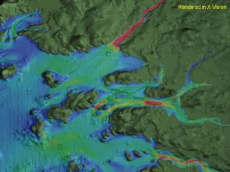
Tidal currents and particle tracking This is an overview of a section of the coastline in Maine, near the Narraguagus river. The animation shows the results of DHI's MIKE 21 hydrodynamic model in a tidal zone. Baird's Lagrangian Particle Tracking Model (LPTM) was used to inject a steady stream of particles into the flow at three separate locations, which adds another dimension of understanding to the current patterns not available with traditional vector plotting. |
|
|
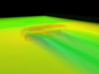
3D flow patterns and eddies This visualization shows a stream of particles flowing around an obstacle in a test channel. It is a volume rendering of current speeds computed using Baird's MISED 3D hydrodynamic model. Using Baird's Lagrangian Particle Tracking Model, several particle sources were injected into the volume upstream of the structure in order to highlight the dominant flow patterns. Another two particle sources were added at the downstream base of the structure to visualize the resultant vorticity. The model, and subsequent visualizations, were used for assessing structural alternatives prior to implementation. |
|
|
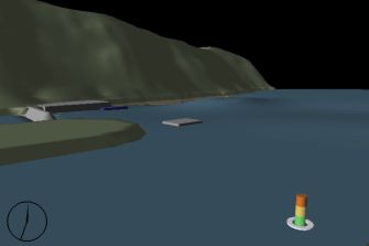
Event re-creation This animation shows a simulation of an actual landslide-induced tsunami in 1994 at the harbor in Skagway, Alaska. Solids models are used to provide landmarks for orientation. A dynamic representation of a tide gauge was added in the foreground, which moves according to the actual recorded water levels during the event. The square structure in the center represents a 4400 ton floating concrete ferry dock measuring about 100 feet wide, which broke its 13 mooring chains and travelled an approximate 60 feet longitudinally. Maximum wave heights exceeded 30 feet outside the harbor. |
|
|
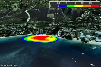
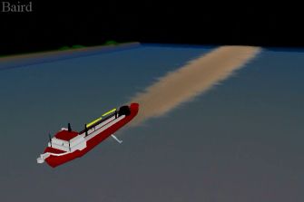
Environmental impact assessment Fly-through around an offshore dredging operation showing a sediment plume volume and accumulated bottom deposition. This animation was produced during the model testing phase in order to measure the limits and performance of the plume model. The timeline is accelerated considerably. |
|
|
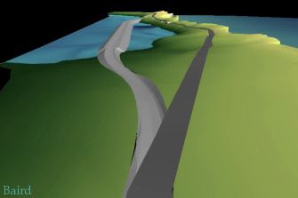
Design scenarios This animation shows a fly-through of a project site in Eleuthra, Bahamas. The Glass Window causeway was the preferred alternative to provide safe passage in lieu of the existing bridge that was exposed to extreme wave conditions along the bight. Representational solids models are used to depict the existing bridge and proposed causeway, which coupled with a fly-through, provides a real indication of the scale of the project relative to the surrounding topography. |
|